Grafik / Weltkarten / Worldmaps von Antiquariat Steffen Völkel GmbH Steffen Völkel

"Mappemonde ou carte reduite des parties connues du globe pour servir au Voyage de La Perouse" - Wo…
von Jean-Francois de la (1741-1788), Pérouse Verlag: Paris
1798. Großformatige Kupferstich-Karte aus dem 18. Jh. -- Bildmasse: ca. 93 x 58 cm. -- gut erhalten. || Large copper engraved map from the 18th century. -- in good condition. || This inaugural edition presents a significant and expansive map of the world, highlighting the voyage of La Perouse.…

"Carte des deux regions Polaires" - Polar America Australia Europe Africa Asia Russia Weltkarte wor…
von Georges-Louis Leclerc de (1707-1788), Buffon
ca. 1780. Bildmaße: ca. 22 x 44 cm -- Original Kupferstich-Karte -- gut erhalten. || Original engraved map. -- in very good condition. || Georges-Louis Leclerc, Comte de Buffon (1707-1788) war bedeutender ein französischer Naturforscher im Zeitalter der Aufklärung. Sein Hauptwerk ist die "Histo…

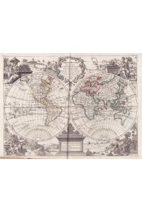
"Mappe-Monde ou Description du Globe Terrestre. " - World Map Weltkarte Mappe Monde
von Robert Janvier Verlag: Paris
1762. Original handkolorierte Kupferstich-Karte von 1762. -- Blattmasse: ca. 37 x 53 cm. -- teils leicht fleckig, leicht fleckig im Außenrand, sonst gut erhalten. || Original hand-colored engraved map from 1762. -- partly slightly stained, slightly stained in the outer margin, otherwise in good…

"Carte de l'Ancien Continent" - Old World / Alte Welt / World Map Mappemonde Weltkarte / Africa Eur…
von Didier (1723-1786), Georges-Louis Leclerc de Buffon (1707-1788), Robert de Vaugondy Verlag: Paris
1749. Original Kupferstich-Karte von 1749. -- Blattmasse: ca. 25 x 19 cm. -- gut erhalten. || Original engraved map from 1749. -- in very good condition.
"Mappe Monde qui comprend . . " - Weltkarte world map Mappemonde Karte map
von Georges Louis (1707-1790), Le Rouge Verlag: Paris, Crepy
1767. Original grenzkolorierte Kupferstich-Karte von 1767. Blattmaße: ca. 33, 5 x 24 cm -- unterer linker Rand gebräunt und mit Läsuren, sonst gut erhalten ||Original hand colored copper engraved map from 1767. -- lower left edge browned and with damage, otherwise in very good condition.

"Mappemonde ou Description du Globe Terrestre" - Weltkarte world map mappemonde Karte
von Didier Robert (1688-1766), de Vaugondy Verlag: Paris, Delamarche
ca. 1750. Großformatige altkolorierte original Kupferstich-Karte von ca. 1750 - Blattmasse: ca. 51 x 76 cm -- im Mittelbug leicht gebräunt, leicht fleckig, mit alten Faltspuren, sonst gut erhalten. || Large old colored original copper engraved map from ca. 1750. -- with some old fold marks, sli…

"Orbis vetus in utrâque continente juxta mentem Sansonianam distinctus, nec non observationibus ast…
von Didier Robert de Vaugondy (1723-1786) Verlag: Paris
1752. Großformatige handkolorierte original Kupferstich-Karte von 1752. - Blattmasse: ca. 51 x 77 cm. -- teils etwas fleckig, im Mittelbug leicht gebräunt, mit alten Faltspuren, sonst gut erhalten. || Large handcolored original engraved map from 1752. -- with old fold marks, slightly browned on…

"The World" - Weltkarte / world map / Mappemonde
von Arrowsmith Verlag: London, Longman & Rees
1806. Original Kupferstich-Karte aus dem frühen 19. Jahrhundert. -- Blatt-Maße: ca. 27 x 41 cm. -- gut erhalten. || Original copper engraved map from the early 19th century. -- in very good condition.

"Geographiae Antiquae Tab. I. " - Africa Afrika Afrique / Europe Europa / Asia Asien Asie
von Alexander Macpherson Verlag: London, Longman & Rees
1818. Original Kupferstich-Karte aus dem frühen 19. Jahrhundert. -- Blatt-Maße: ca. 27 x 41 cm. -- gut erhalten. || Original copper engraved map from the early 19th century. -- in very good condition.

"Sphere Armillaire Oblique" - Armillary sphere Compass Rose world map globe Globes
von Pierre Bourgoin Verlag: Paris
ca. 1770. Sehr seltene, teils altkolorierte Kupferstich-Karte von ca. 1770. Blatt-Maße: ca. 43 x 57 cm. -- im oberen und unteren Außenrand mit dünner Wurmspur, sonst gut erhalten. || Very rare partly hand colored map from c. 1770. -- Very uncommon map by this little-known French cartographer. -…