
"Virginia et Nova Francia" - Virginia Canada Kanada North America Amerika map Karte carte
von Jodocus Hondius (1563-1612); Verlag: Amsterdam, J. Hondius
1618. Original Kupferstich-Karte aus Bertius' "Atlas Minor" gedruckt in Amsterdam bei J. Hondius im Jahre 1618. Mit lateinischem Text auf der Rückseite. -- Blatt-Maße: ca. 12 x 19 cm. -- gut erhalten. || Original engraved map out of Bertius' "Atlas Minor", published by J. Hondius in Amsterdam i…
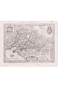
"Virginia" - Virginia America Amerika Chesapeake Bay Maryland Delaware New York United States Penns…
von Gerhard (1512-1594), Mercator Verlag: Amsterdam, Janssonius
1651. Rare map. Despite its small size, it is filled with towns with both English and Native names, including Jamestown (Jamestowne). Blatt-Maße: ca. 17, 5 x 23 cm -- Original Kupferstich-Karte von Gerard Mercator. Rückseitig mit deutschem Text. Aus der deutschen Ausgabe des "Atlas Minor" von 1…

BAYLY, Thomas H. Bayly (1810-1856), Virginia congressman
c.1850 portrait original woodcut, sheet size approx. 22 x 14 cm, some spotting Antique Print c.1850
323,40 EUR
![The Diary of Virginia Woolf. [Bde. 1 - 4].](/produkt-bilder-vorschau/102523010/1/the-diary-of-virginia-woolf-bde-1-4.jpg)
The Diary of Virginia Woolf. [Bde. 1 - 4].
von Virginia Woolf Verlag: London, The Hogarth Press, 1977 - 1982
4°, XXVIII, 356, XXI, 371, XIII, 384 u. XIII, 402 S., OLwd. m. OU, OUs tlw. etw. lichtrandig, 1 am Rücken tle. ausgeblichen, Bücher tadellos., Jeweils EA. Bd. 1: 1915 - 1919; Bd. 1920 - 1924; Bd. 3: 1925 - 1930; Bd. 4: 1931 - 1935.
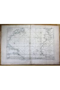
North Atlantic Ocean America Canada Africa Spain Virginia sea chart map
1742. (MN 32971) "Carte Reduite de l'Ocean Occidental" very rare large original engraved sea chart from 1742 shows the North Atlantic with coastal information on North and South America, Africa, Spain and France and many islands size of sheet: ca. 96 x 64 cm (circa 37.8 x 25.2 inches) some st…

Aesthetic Plastic Surgery. Second Edition. Volume I and Volume II. Illustrations by DaisyStilwell a…
von Gregry LaTrenta Verlag: W. B. Saunders Company, Philadelphia - London - T…
2 Bände zusammen = komplett, 2 Volumes, 1994 XVII, 537, 18; XVII, 538-1254, 18 S., Gr. 4° (Groß-Quart, 35 bis 40 cm). silbergeprägtes Orig.- Leinen (Hardcover). Sehr gut erhalten. - Very fine.
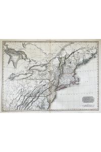
"United States of America. Northern Part. " - New England United States North America New York Virg…
von John (1758-1826), Pinkerton Verlag: London
1810. Seltene großformatige handkolorierte Kupferstich-Karte aus John Pinkerton's "Modern Atlas" von 1815. -- Blatt-Maße: ca. 75 x 55 cm. -- gut erhalten. || Rare large handcolored engraved map out of John Pinkerton's "Modern Atlas" published in London in 1815. -- in good condition. || Dies ist…

Intracranial Pressure and Neuromonitoring in Brain Injury - Proceedings of the Tenth International…
2012 Kartoniert, 452 Seiten, 280mm x 210mm x 25mm, Sprache(n): eng This volume contains the most recent works on intracranial pressure and neuromonitoring in brain injury selected from 300 abstracts submitted to the 10th International Symposium on Intracranial Pressure. It includes state of the…
365,35 EUR

Intracranial Pressure and Neuromonitoring in Brain Injury - Proceedings of the Tenth International…
1998 Gebunden, 452 Seiten, 285mm x 215mm x 33mm, Sprache(n): eng This volume contains the most recent works on intracranial pressure and neuromonitoring in brain injury selected from 300 abstracts submitted to the 10th International Symposium on Intracranial Pressure. It includes state of the ar…
365,35 EUR
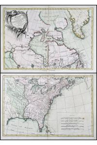
"Partie de L'Amerique Septentrionale, qui comprend le Canada, la Louisiane, le Labrador, le Groenla…
von Rigobert (1727-1794), Bonne Verlag: Paris
1771. Original handkolorierte Kupferstich-Karte. -- Blattmasse: ca. 53 cm x 77 cm, Kartenmasse: ca. 42 cm x 62 cm. - 2 Karten. - teils leicht fleckig, sonst gut erhalten. || -- Original hand-colored engraved map. -- rare two sheet map! - partly slightly stained, otherwise in very good condition.
- Volltext
- Virginia
- Preis
- 300€ bis 500€
Speichern Sie Ihre Suche als Auftrag für einen späteren Zeitpunkt und lassen Sie sich bei neu eintreffenden Artikeln automatisch per E-Mail benachrichtigen (optional)!