
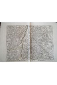
"Carte de Provence et des terres adjacentes" - Provence Marseille Aix Toulon Frejus Arles Nice map…
von Guillaume Delisle Verlag: Paris
1715. Original altkolorierte Kupferstich-Karte von Guillaume Delisle von 1715. -- Blattformat: ca. 54 x 74 cm. -- gut erhalten. || Original old colored engraved map by Guillaume Delisle. – in good condition. || Dies ist ein Original! - Kein Nachdruck! - Keine Kopie! -- This is an original! - No…

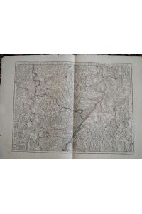
"Partie meridionale du Piemont et du Monferrat" - Piemonte Savona Nice Cuneo Sanremo Imperia map Ka…
von Guillaume Delisle Verlag: Paris
1707. Original altkolorierte Kupferstich-Karte von Guillaume Delisle von 1707. -- Blattformat: ca. 54 x 74 cm. -- gut erhalten. || Original old colored engraved map by Guillaume Delisle. – in good condition. || Dies ist ein Original! - Kein Nachdruck! - Keine Kopie! -- This is an original! - No…

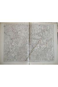
"Carte de Tartarie" - Tartary Russia Siberia Sibirien Siberie China Korea Asia Russland
von Guillaume Delisle Verlag: Paris
1706. Original altkolorierte Kupferstich-Karte von Guillaume Delisle von 1706. -- Blattformat: ca. 54 x 74 cm. -- gut erhalten. || Original old colored engraved map by Guillaume Delisle. – in good condition. || Dies ist ein Original! - Kein Nachdruck! - Keine Kopie! -- This is an original! - No…

"Theatrum historicum . . . pars orientalis" - Middle East / Turkey / Iran / Black Sea / Arabia / Pe…
von Guillaume Delisle Verlag: Paris
1705. Original altkolorierte Kupferstich-Karte von Guillaume Delisle von 1705. -- Blattformat: ca. 54 x 74 cm. -- gut erhalten. || Original old colored engraved map by Guillaume Delisle. – in good condition. || Dies ist ein Original! - Kein Nachdruck! - Keine Kopie! -- This is an original! - No…

"Carte des Pays Bas Catholiques" - Belgien Belgique Holland Luxemburg Belgium map Karte Covens Mort…
von Guillaume Delisle Verlag: Paris, Buache
1745. Original handkolorierte Kupferstich-Karte von 1745. -- Blattmasse: ca. 52 x 70 cm. -- am oberen Außenrand teils leicht fleckig, sonst gut erhalten. || Original hand-colored engraved map from 1745. -- partly slightly stained on the upper outer margin, otherwise in good condition. || Dies i…
"Orbis Veteribus Noti Tabula Nova e Regia Scientiarum Academia".
von Guillaume DELISLE Verlag: Paris,
1714. 49 cm Durchmesser Blattgröße 52 x 74 cm altkolorierte Kupferstichkarte der östlichen Hemisphäre von Guillaume Delisle mit Australien, entsprechend der beiden Reisen von Abel Tasman (1642-1644). - Ränder mit senkrechten Falzen, gut erhaltene Karte
Le cours du Rhin au deffus de Strasbourg jusqua Worms et les pais adjacens. Original Kupferstichkar…
von Guillaume Delisle
Etwas fleckig. Verso mit Handschrift von alter Hand. - Stighly stained, verso with old handwriting. oute edge with little hole. - We offer Combined Shipping
90,00 EUR
Le cours du Rhin depuis de Strasbourg jusqua Worms et les pais adjacens. Original Kupferstichkarte,…
von Guillaume Delisle
1730. Breiter weisser Rand (etwas lädiert) - wide white border (stightly damaged). We offer Combined Shipping C2-K
120,00 EUR
Le cours du Rhin depuis Strasbourg jusqua Worms et les pays adjacens. Original Kupferstichkarte, gr…
von Guillaume Delisle
Etwas fleckig. Unterrand mit kl. Einrisse und leichte Knickspuren. - Stighly stained, outer edge with tear. - We offer Combined Shipping C2-K
90,00 EUR

"Carte d'Artois et des Environs Vel Mappa Specialis Comitatus Artesiae. " - Artois Lille Hesdin Bet…
von Guillaume (1675-1726), Delisle Verlag: Nürnberg, Homann Erben
1750. Original altkolorierte Kupferstich-Karte von ca. 1750. -- Blatt-Maße: ca. 55 x 64 cm. -- gut erhalten. || Original old colored copper engraved map from around 1750. -- in good condition. || Dies ist ein Original! - Kein Nachdruck! - Keine Kopie! -- This is an original! No copy! - No repri…
- Autor
- Guillaume Delisle
Speichern Sie Ihre Suche als Auftrag für einen späteren Zeitpunkt und lassen Sie sich bei neu eintreffenden Artikeln automatisch per E-Mail benachrichtigen (optional)!