
"Jamaica" - Jamaica island America map Karte Thomson
von John Thomson Verlag: Edinburgh
1817. original altkolorierte Kupferstich-Karte aus: "Thomson: New General Atlas" | original old colored copper engraved map out of "Thomson: New General Atlas" | Blatt-Format: ca. 72 x 53 cm - gut erhalten. | size of sheet: circa 28.3 x 20.8 inches - good condition.

"United States of America" - United States of America USA map Karte Thomson
von John Thomson Verlag: Edinburgh
1817. original altkolorierte Kupferstich-Karte aus: "Thomson: New General Atlas" | original old colored copper engraved map out of "Thomson: New General Atlas" | Blatt-Format: ca. 72 x 53 cm - gut erhalten. | size of sheet: circa 28.3 x 20.8 inches - good condition.

"West India Islands" - West Indies Guadeloupe Antigua Marie Galante island map Karte Thomson
von John Thomson Verlag: Edinburgh
1817. original altkolorierte Kupferstich-Karte aus: "Thomson: New General Atlas" | original old colored copper engraved map out of "Thomson: New General Atlas" | Blatt-Format: ca. 72 x 53 cm - im unteren Außenrand mit kleinem Ausriss beim Mittelbug, sonst gut erhalten. | size of sheet: circa 28…

"West India Islands" - West Indies Martinique Dominica island America map Karte Thomson
von John Thomson Verlag: Edinburgh
1817. original altkolorierte Kupferstich-Karte aus: "Thomson: New General Atlas" | original old colored copper engraved map out of "Thomson: New General Atlas" | Blatt-Format: ca. 72 x 53 cm - mit kleinem Löchlein im Mittelbug, oben knapp beschnitten, leicht fleckig, sonst gut erhalten. | size…

The Straits of Malacca, Indo-China, and China. Or, Ten Years' Travels, Adventures, and Residence Ab…
von John Thomson
2024 Kartoniert, 596 Seiten, 210mm x 148mm x 41mm, Sprache(n): eng Reprint of the original, first published in 1875.
79,90 EUR

The Straits of Malacca, Indo-China, and China. Or, Ten Years' Travels, Adventures, and Residence Ab…
von John Thomson
2024 Gebunden, 596 Seiten, 216mm x 153mm x 44mm, Sprache(n): eng Reprint of the original, first published in 1875.
99,90 EUR
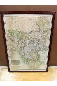
Turkish dominions in Europe. Grenzkolorierter Stahlstich aus: Thomsons New General Atlas.
von John Thomson Verlag: Edinburgh
1815 Bildmaß der Darstellung ca. 47 x 34 cm ( Höhe x Breite ), alt unter Glas schlicht gerahmt. ( Rahmenmaß: 51, 5 x 37, 5 cm ). Das Blatt zeigt das jetzige Griechenland, die Inseln der Ägäis, Kleinasien und einen Teil der Küste Italiens. Mit Meilenzeiger. Das Blatt gebräunt, leicht lichtrandig…
250,00 EUR

Epicus
von John Thomson
2012 Kartoniert, 364 Seiten, 280mm x 210mm x 20mm, Sprache(n): eng John E. Thomson, a native of California, is a founding member of the Clarksville Region Historical Society, and has been a member of its Board of Directors for a number of years. During his professional career John held research…
40,94 EUR

Tables of Interest at 3, 4, 4. 5, and 5 Percent from to 10, 000 and from 1 to 365 Days in a Regular…
von John Thomson Verlag: Nabu Press,
2010. Taschenbuch, Größe: 18.9 x 2.8 x 24.6 cm 546 Seiten Gepflegter, sauberer Zustand. 9324955/2
- Sonderaktion: 10% Rabatt bis 04.07.2024
62,10 EUR
55,89 EUR

The Straits of Malacca, Indo-China, and China; Or, Ten Years` Travels, Adventures, and Residence Ab…
von John Thomson Verlag: Rarebooksclub.com,
2012. Taschenbuch, Größe: 18.9 x 0.8 x 24.6 cm 0 Gepflegter, sauberer Zustand. 5811693/2
- Sonderaktion: 10% Rabatt bis 04.07.2024
43,52 EUR
39,17 EUR
- Autor
- John Thomson
Speichern Sie Ihre Suche als Auftrag für einen späteren Zeitpunkt und lassen Sie sich bei neu eintreffenden Artikeln automatisch per E-Mail benachrichtigen (optional)!