Alte Landkarten von Alte Bücherwelt Antiquariat Ernst Reiter

Sketch Map of the Dutch Possessions in the Indian Archipelago
von A. Fullarton Verlag: London, A. Fullarton, ca. 1860.,
41 x 29 cm Sketch Map of the Dutch Possessions in the Indian Archipelago, gest. v. J. Bartholomew, hrsg. A. Fullarton, London, ca. 1860, Orig. Stahlstich, grenzkoloriert, Format 41 x 29 cm, Blattgröße 47, 5 x 31 cm, sehr guter Zustand.
42,00 EUR

Partie Septentrionale du Royaume de Naples
von Ing. Hydrographe Bonne Verlag: 34 x 23 cm, 1787.,
Partie Septentrionale du Royaume de Naples, par M. Bonne, Ing. Hydrographe de la Marine, hrsg. 1787, Orig. Kuper, koloriert, Format 34 x 23 cm, Blattgröße 40 x 29 cm, sehr guter Zustand
94,00 EUR

Le Nord de L'Europe Original Landkarte Skandinavien
von M Bonne Verlag: 1783.,
31,5 x 21,5 cm Original-Landkarte Le Nord de L'Europe contenant Le Danemark, La Norwege, La Suede et La Ponie, avec la Majeure Partie de la Russie Europeene, par M. Bonne, Ing. Hydr. de la Marine, hrsg. 1783, Original Kuper, koloriert, Format 31, 5 x 21, 5 cm, Blattgröße 35, 5 x 25, 5 cm, sehr…
51,00 EUR

Berg S. Winoc, Original-Kupferstich alte Landkarte
Verlag: 1720.,
20,5 x 15,5 cm Original-Kupferstich m. Kartusche, Titel "Berg S. Winoc", Format 20, 5 x 15, 5 cm, ca. 1720, guter Zustand.
51,00 EUR
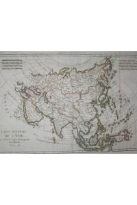
Carte de L'Asie
von Ing. Hydrographe Bonne Verlag: 1781.,
32,5 x 21,5 cm Carte Generale de L'Asie par M. Bonne, Ingen. Hydrographe de la Marine, hrsg. 1781, Kupfer tlw. koloriert, Form. 32, 5 x 21, 5 cm, Blattgr. 36, 5 x 26 cm, sehr guter Zustand. Best.Nr. ALK-035
72,00 EUR
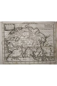
Original-Landkarte Asien (L'Asie)
Verlag: 1767.,
19 x 16,5 cm Original-Landkarte (Kupfer), L'Asie (Asien), suivant les dernieres observations de L'Academie Royale des Sciences, 18 x 14, 5 cm, Blattgröße 19 x 16, 5 cm, etwas beschmutzt
38,00 EUR
A New Map of Denmark and Holstein
von Robert Wilkinson Verlag: London, Rob. Wilkinson, 1794.,
33,5 x 27 cm A New Map of Denmark and Holstein, hrsg. London, W. Wilkinson, 1794, gest. von Hirrisen, Format 33, 5 x 27 cm, Kupfer koloriert, guter Zustand.
60,00 EUR

A Map of the Empire of Germany Landkarte Deutsches Reich
Verlag: 1786.,
31,5 x 20,5 cm A Map of the Empire of Germany divided into Circles, from the best Authorities, hrsg. 1786 Brookes Gazetteer, Original-Kupferstich koloriert, alte Landkarte Deutsches Reich, mit dekorativer Kartusche rechts unten, Format 27, 5 x 21, 5 cm, am unteren Rand knapp beschnitten, guter…
60,00 EUR

France dresse par Herisson
von Herisson Verlag: 1830.,
39 x 30 cm Original-Landkarte France dressee par Herisson, hrsg. 1830, mit 20 kolorierten Flaggen seitlich (pavillons des differentes puisances), Kupfer, koloriert, guter Zustand, Format 39 x 30 cm
60,00 EUR
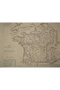
An Exact Map of the Principal Rivers in France
von Senex I. scupt Delin Verlag: 1711.,
33,5 x 24 cm Original-Landkarte, Kupferstich, An exact map of the principal rivers of France, Fluviorum in Gallia potiorum Talvula, I. Senex, Sculpt., hrsg. 1711, Format 33, 5 x 24 cm (Blattgröße), guter Zustand.